|
TERMS OF USE:
This free image can only be used for non-commercial, personal
website use only. THIS IMAGE CANNOT BE
used in galleries, downloaded to your computer, posted on sites for
others to use, manipulated, downsized, or upsized. If you are confused about the
terms of use or have any questions then contact us before using the image.
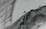
Free Picture: Richat Structure, Mauritania
|
Description
The prominent circular feature seen here, known as the Richat Structure, in the Sahara desert of Mauritania, is often noted by astronauts because it forms a conspicuous 50-kilometer-wide (30-mile-wide) bull's-eye on the otherwise rather featureless expanse of the desert. Initially mistaken for a possible impact crater, it is now known to be an eroded circular anticline (structural dome) of layered sedimentary rocks. Extensive sand dunes occur in this region and the interaction of bedrock topography, wind, and moving sand is evident in this scene. Note especially how the dune field generally ends abruptly short of the cliffs as wind from the northeast (upper right) apparently funnels around the cliff, sweeping clean areas near the base of the cliff (particularly at the cliff point to the northwest, upper left, of the Richat Structure). Note also the isolated peak within the dune field. That peak captures some sand on its windward side, but mostly deflects the wind and sand around its sides, creating a sand-barren streak that continues far downwind. To the west (left), a north-south trending bedrock ridge breaks up the sand field, and downwind from the ridge, streaks of dunes occur at certain locations. Upon close inspection, these streaks can be seen to be associated with saddles (low points) along the ridge, where sand preferentially passes over the ridge. This again shows how topographic features control the distribution of sand across the terrain. This anaglyph was created by draping a Landsat reflectance infrared image over an SRTM elevation model, and then generating two differing perspectives, one for each eye. When viewed through special glasses, the anaglyph is a vertically exaggerated view of the Earth's surface in its full three dimensions. Anaglyph glasses cover the left eye with a red filter and cover the right eye with a blue filter For vertical scale, note that the prominent cliffs (image center) are about 300 meters (about 1000 feet) tall, the central
Keywords
crater, craters, earth science, geography, jpl, mauritania, nasa, richat structure, sahara desert, topography, anaglyph, free photography, free photo, free photos, free picture, free pictures, free image, free images
|
Similar Free geography Pictures
|
|
|
|


