|
TERMS OF USE:
This free image can only be used for non-commercial, personal
website use only. THIS IMAGE CANNOT BE
used in galleries, downloaded to your computer, posted on sites for
others to use, manipulated, downsized, or upsized. If you are confused about the
terms of use or have any questions then contact us before using the image.
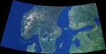
Free Picture: Scandinavia and the Baltic Region
|
Description
Data from the Multi-angle Imaging SpectroRadiometer's vertical-viewing (nadir) camera were combined to create this cloud-free natural-color mosaic of Scandinavia and the Baltic region. The image extends from 64°N, 0°E in the northwest to 56°N, 32°E in the southeast, and has been draped over a shaded relief Digital Terrain Elevation Model from the United States Geological Survey. It is displayed in an equidistant conic projection.
The image area includes southern Norway, Sweden and Finland, northern Denmark, Estonia, Latvia and part of western Russia. Norway's rugged western coastline is deeply indented by fjords. Elongated lakes, formed by glacial erosion and deposition, are characteristic of the entire region, and are particularly dense throughout Finland and Sweden. Numerous islands are present, and a virtually continuous chain of small, scattered islands occur between Sweden and Finland. The northern and eastern waters of the Baltic Sea are almost fresh, since the Baltic receives saltwater only from the narrow and shallow sounds between Denmark and Sweden that connect it to the North Sea. Most of the major cities within the image area are coastal, including St. Petersburg, Stockholm, Helsinki, Riga, and Oslo.
Keywords
baltic region, baltic sea, continent, continents, denmark, earth science, estonia, finland, geography, helsinki, jpl, latvia, nasa, north sea, norway, oslo, riga, russia, scandinavia, st petersburg, stockholm, sweden, scandinavia and the baltic region, free photography, free photo, free photos, free picture, free pictures, free image, free images
|
Similar Free geography Pictures
|
|
|
|


