|
TERMS OF USE:
This free image can only be used for non-commercial, personal
website use only. THIS IMAGE CANNOT BE
used in galleries, downloaded to your computer, posted on sites for
others to use, manipulated, downsized, or upsized. If you are confused about the
terms of use or have any questions then contact us before using the image.
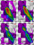
Free Picture: Distribution Patterns, Hurricanes Katrina and Rita
|
Description
The above images, derived from NASA QuikSCAT satellite data, show the extensive pattern of rain water deposited by Hurricanes Katrina and Rita on land surfaces over several states in the southern and eastern United States. These results demonstrate the capability of satellite scatterometers to monitor changes in surface water on land. The color scale depicts increases in radar backscatter (in decibels) between the current measurement and the mean of measurements obtained during the previous two weeks. The backscatter can be calibrated to measure increases in surface soil moisture resulting from rainfall. The yellow color corresponds to an increase of approximately 10 percent or more in surface soil moisture according to the calibration site of Lonoke, Ark. The two hurricanes deposited excessive rainfall over extensive regions of the Mississippi River basin. Basins the size of the Mississippi can take up to several weeks before such excess rainfall significantly increases the amount of river discharge in large rivers such as the Mississippi. With hurricane season not over until November 30, the potential exists for significant flooding, particularly if new rain water is deposited by new hurricanes when river discharge peaks up as a result of previous rainfalls. River discharge should be closely monitored to account for this factor in evaluating potential flood conditions in the event of further hurricanes.
Keywords
earth science, hurricane, hurricane katrina, hurricane rita, hurricanes, katrina, map, maps, mississippi river basin, rita, science, united states, weather, hurricanes katrina and rita, free photography, free photo, free photos, free picture, free pictures, free image, free images
|
Similar Free map Pictures
|
|
|
|