|
TERMS OF USE:
This free image can only be used for non-commercial, personal
website use only. THIS IMAGE CANNOT BE
used in galleries, downloaded to your computer, posted on sites for
others to use, manipulated, downsized, or upsized. If you are confused about the
terms of use or have any questions then contact us before using the image.
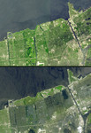
Free Picture: Hurricane Katrina Aftermath
|
Description
Seventeen days after Hurricane Katrina flooded New Orleans, much of the city is still under water. In this pair of images from the Advanced Spaceborne Thermal Emission and Reflection Radiometer on NASA's Terra satellite, the affected areas can clearly be seen. The top image mosaic was acquired in April and September 2000, and the bottom image was acquired September 13, 2005. The flooded parts of the city appear dark blue, such as the golf course in the northeast corner, where there is standing water. Areas that have dried out appear light blue gray, such as the city park in the left middle. On the left side of the image, the failed 17th street canal marks a sharp boundary between flooded city to the east, and dry land to the west.
Keywords
aftermath, aftermath of hurricane katrina, earth science, flood, flooding, flooding in the aftermath of hurricane katrina, floods, geography, hurricane katrina, jpl, katrina, katrina aftermath, louisiana, nasa, new orleans, post katrina, weather, the big easy, free photography, free photo, free photos, free picture, free pictures, free image, free images
|
Similar Free geography Pictures
|
|
|
|


