|
TERMS OF USE:
This free image can only be used for non-commercial, personal
website use only. THIS IMAGE CANNOT BE
used in galleries, downloaded to your computer, posted on sites for
others to use, manipulated, downsized, or upsized. If you are confused about the
terms of use or have any questions then contact us before using the image.
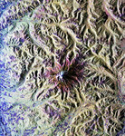
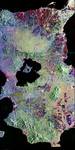
Free Picture: Forecast of San Francisco Earthquake Risk
|
Description
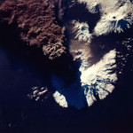
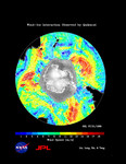
This illustration depicts synthetic aperature radar patterns of seismic deformations associated with a model earthquake on the San Francisco section of the San Andreas Fault (depicted in yellow). Each complete interferometric fringe color cycle corresponds to a displacement of 56 millimeters (2.2 inches). A new computer simulation developed by scientists from JPL; the University of California, Davis; and other institutions concludes the region has a 25 percent chance of a magnitude 7 or greater earthquake in the next 20 years, and a roughly 1 percent chance of such an earthquake each year, according to the "Virtual California" computer simulation. The Virtual California approach to earthquake forecasting is similar to the computer models used for weather forecasting. A previous forecast of earthquake hazards, the Working Group on California Earthquake Probabilities, used records of past earthquakes to calculate the probability of future ones. The Virtual California model includes 650 segments representing the major fault systems in California, including the San Andreas fault responsible for the 1906 San Francisco earthquake. The simulation takes into account the gradual movement of faults and how they interact with each other. The researchers used the model to simulate 40,000 years of earthquakes in California. They found almost 400 major (magnitude 7 or above) earthquakes at an average interval of 101 years. The simulation data indicates a 25 percent chance of another such earthquake in the next 20 years, a 50 percent chance in the next 45 years and a 75 percent chance by 2086.
Keywords
california, earth science, earthquake, earthquake risk, earthquakes, fault, faults, jpl, nasa, san andreas fault, san francisco, san francisco earthquake risk, science, virtual california, forecast of san francisco earthquake risk, free photography, free photo, free photos, free picture, free pictures, free image, free images
|
Similar Free earth science Pictures
|
|
|
|