|
TERMS OF USE:
This free image can only be used for non-commercial, personal
website use only. THIS IMAGE CANNOT BE
used in galleries, downloaded to your computer, posted on sites for
others to use, manipulated, downsized, or upsized. If you are confused about the
terms of use or have any questions then contact us before using the image.
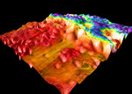
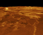
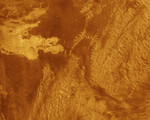
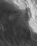
Free Picture: Lakshmi Planum and Maxwell Montes
|
Description
This Magellan full resolution radar image is centered at 65 degrees north latitude, zero degrees east longitude, along the eastern edge of Lakshmi Planum and the western edge of Maxwell Montes. The plains of Lakshmi are made up of radar-dark, homogeneous, smooth lava flows. Located near the center of the image is a feature previously mapped as tessera made up of intersecting 1- to 2-km (0.6 to 1.2 miles) wide graven. The abrupt termination of dark plains against this feature indicates that it has been partially covered by lava. Additional blocks of tessera are located along the left hand edge of the image. A series of linear parallel troughs are located along the southern edge of the image. These features, 60- to 120-km (36- to 72- miles) long and 10- to 40- km (6- to 24- miles) wide are interpreted as graben. Located along the right hand part of the image is Maxwell Montes, the highest mountain on the planet, rising to an elevation of 11.5 km (7 miles) and is part of a series of mountain belts surrounding Lakshmi Planum. The western edge of Maxwell shown in this image rises sharply, 5.0 km (3.0 miles), above the adjacent plains in Lakshmi Planum. Maxwell is made up of parallel ridges 2- to 7-km (1.2- to 4.2 miles) apart and is interpreted to have formed by compressional tectonics. The image is 300 km (180 miles) wide.
Keywords
astronomy, jpl, lakshmi, lakshmi planum, lakshmi planum and maxwell montes, maxwell montes, venus, nasa, free photography, free photo, free photos, free picture, free pictures, free image, free images
|
Similar Free Pictures of venus
|
|
|
|