Egypt Sand Dunes #3622


#3622 Egypt Sand Dunes by JVPD
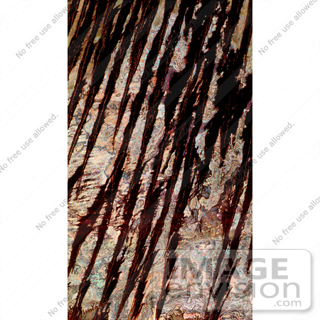
NASA radar image of west central Egypt showing detailed patterns of eroded sedimentary rock formations emerging through a vast sea of sand dunes. The broad black bands that dominate the image are thick ridges of sand known as longitudinal dunes. In this region of the Sahara, a single ridge may be as long as several hundred kilometers. Thin red lines within the black bands are bright reflections from the steep crests of the sand ridges. Between the dunes are colorful patterns of rock outcrops that are either exposed at the surface or covered with very thin layers of sand that the radar "sees.

Photo Credit: NASA/JPL [0003-0701-1019-1835] by 0003

Similar Images:

#3573 Great Wall of China From Space by JVPD
#19245 Photo of the Artificial Palm Island, Palm Jumeirah, on the Persian Gulf in Dubai by JVPD
#3253 Lost Hills by JVPD
#25455 Stock Photo of a Vetical Cropped Image of the State of Florida as Seen From Space by JVPD
#2898 Pulau Kimaam, West Papua by JVPD
#26949 Stock Photography of a Map of the Contiguous United States of America and the Great Lakes by JVPD
#35500 Geography Stock Photo Of The Strait Of Magellan, Chile As Seen From Space by JVPD
#2882 Bosporus Strait and Istanbul, Turkey by JVPD
#2685 Picture of World Globes - Three Views of Earth by JVPD
#3343 Cape Cod From Space by JVPD
#3619 Cape Cod From Space by JVPD
#3298 Mexicali, Calexico by JVPD
#3323 Liquefaction Effects, Bhuj Earthquake by JVPD
#3239 Republic of Fiji by JVPD
#3626 Boston From Space by JVPD
More Geography Photos

Keywords

egypt sand dunes, from space, geography, jpl, nasa, sahara, sahara desert, sand dunes, sand dunes from space, view from space