
|
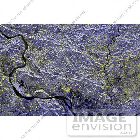
Image of a mineral-rich region in southern China is being used by geologists to identify potential new areas for mineral exploration. The area shown is the vicinity of the city of Zhao Qing, the light blue area along the banks of the River Xi Jiang in the lower left. This is in the southern Chinese province of Guangdong, about 75 kilometers (46 miles) west of Guangzhou (Canton). The largest gold mine in southern China is located in the far upper left of the image along a brightly reflective mountain ridge. Using the radar image as a guide, geologists are tracing the extension of the ridge structure to the east (right) to identify possible mining areas. Radar imaging is especially useful for this purpose because of its sensitivity to subtle topographic structure, even in areas such as these, which have a dense vegetation cover. The Xi Jiang area is one of the most productive mining regions in China, with deposits of tungsten, lead, zinc and gold. Photo Credit: NASA/JPL [0003-0701-1019-1623] by 0003
|
Keywords
china, from space, geography, guangdong, guangzhou, jpl, mineral resources, nasa, river xi jiang, view from space, xi jiang, zhao qing
|
|


