
|
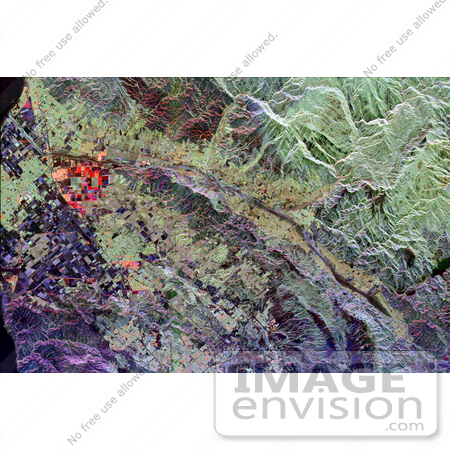
NASA radar image of Ventura County, California from space, featuring the Santa Clara River valley and the surrounding mountains. The river valley is the linear feature that extends from the lower right to the upper left (east to west), where it empties into the Pacific Ocean (dark patches in upper and lower left). The cities of Ventura and Oxnard are seen along the left side of the image. Simi Valley is located in the lower center of the image, between the Santa Monica Mountains (purple area in lower left) and the Santa Susanna Mountains to the north. This area of California is known for its fruit; strawberry fields are shown in red and purple rectangular areas on the coastal plain, and citrus groves are the yellow green areas adjacent to the river. This image is centered at 34.33 degrees north latitude, 119 degrees west longitude. The area shown is approximately 53 kilometers by 35 kilometers (33 miles by 22 miles). Colors are assigned to different radar frequencies and polarizations as follows: red is L-band, horizontally transmitted, horizontally received; green is L-band, horizontally transmitted, vertically received; blue is C-band, horizontally transmitted, vertically received. Photo Credit: NASA/JPL [0003-0701-1018-4945] by 0003
|
Keywords
ca, cali, calif, california, from space, geography, jpl, nasa, oxnard, santa clara river valley, santa monica mountains, santa monica mtns, santa susanna mountains, santa susanna mtns, simi valley, ventura, ventura county, ventura county california, ventura county from space, view from space
|
|


