
|
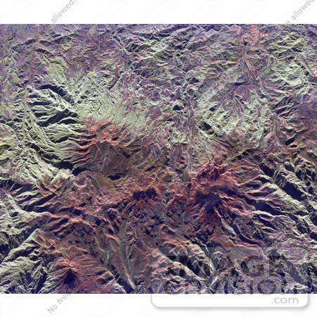
NASA radar image of the Ruiz-Tolima volcanic region in central Colombia, about 150 kilometers (93 miles) west of Bogata. The town of Manizales, Colombia, is the pinkish area in the upper right of the image. Ruiz Volcano, also known as Nevado del Ruiz, is the dark red peak below and right of the image center. A small circular summit crater is visible at the top of Ruiz. Tolima Volcano is the sharp peak near the lower left corner of the image. The red color of the image is due to the snow cover and the lack of vegetation at high elevations in these volcanic mountains. Ruiz Volcano, at 5,389 meters (17,681 feet) elevation, is capped by glaciers. In 1985, an explosive eruption melted parts of these glaciers, triggering mudflows along narrow canyons on the sides of the volcano. The town of Armero, located just off the right side of the image, was buried by mud and 21,000 residents were killed. Scientists are using radar images of these remote yet dangerous volcanoes to understand the threats they pose to local populations. Photo Credit: NASA/JPL [0003-0701-1018-4705] by 0003
|
Keywords
armero, colombia, from space, geography, jpl, manizales, nasa, nevado del ruiz, ruiz tolima, ruiz volcano, ruiz volcano from space, ruiztolima, tolima volcano, view from space, volcano, volcanoes
|
|


