
|
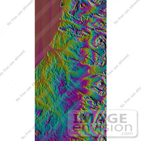
Image showing the western side of the volcanically active Kamchatka Peninsula, Russia. The data are from the first C-band mapping swath of the Shuttle Radar Topography Mission (SRTM). On the left side are five rivers, which flow northwest to the Sea of Okhotsk. These rivers are, from the south to north, Tigil, Amanina, Voyampolka, Zhilovaya, and Kakhtana. The broad, flat floodplains of the rivers are shown in yellow. These rivers are important spawning grounds for salmon. In the right side of the image is the Sredinnyy Khrebet, the volcanic mountain range that makes up the "spine" of the peninsula. The cluster of hills to the lower right is a field of small dormant volcanoes. High resolution SRTM topographic data will be used by geologists to study how volcanoes form and understand the hazards posed by future eruptions. Photo Credit: NASA/JPL/NIMA [0003-0701-0820-0640] by 0003
|
Keywords
amanina, geography, jpl, kakhtana, kamchatka peninsula, kamchatka peninsula russia, nasa, russia, sea of okhotsk, sredinnyy khrebet, tigil, voyampolka, zhilovaya
|
|


