Chernobyl #3376


#3376 Chernobyl by JVPD
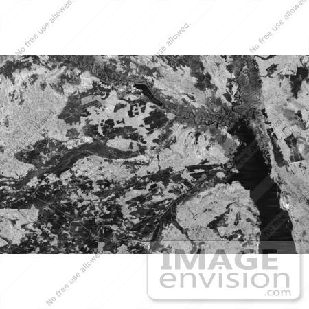
Image of the Chernobyl nuclear power plant and its surroundings, centered at 51.17 north latitude and 30.15 west longitude. The image was acquired by the Spaceborne Imaging Radar-C and X-band Synthetic Aperture Radar aboard the space shuttle Endeavour on its 16th orbit on October 1st 1994. The area is located on the northern border of the Ukraine Republic and was produced by using the L-band (horizontally transmitted and received) polarization. The differences in the intensity are due to differences in vegetation cover, with brighter areas being indicative of more vegetation.

Photo Credit: NASA/JPL-Caltech [0003-0701-0819-4415] by 0003

Similar Images:

#3573 Great Wall of China From Space by JVPD
#19245 Photo of the Artificial Palm Island, Palm Jumeirah, on the Persian Gulf in Dubai by JVPD
#3253 Lost Hills by JVPD
#25455 Stock Photo of a Vetical Cropped Image of the State of Florida as Seen From Space by JVPD
#2898 Pulau Kimaam, West Papua by JVPD
#26949 Stock Photography of a Map of the Contiguous United States of America and the Great Lakes by JVPD
#35500 Geography Stock Photo Of The Strait Of Magellan, Chile As Seen From Space by JVPD
#2882 Bosporus Strait and Istanbul, Turkey by JVPD
#2685 Picture of World Globes - Three Views of Earth by JVPD
#3343 Cape Cod From Space by JVPD
#3619 Cape Cod From Space by JVPD
#3298 Mexicali, Calexico by JVPD
#3323 Liquefaction Effects, Bhuj Earthquake by JVPD
#3239 Republic of Fiji by JVPD
#3626 Boston From Space by JVPD
More Geography Photos

Keywords

chernobyl, chernobyl nuclear power plant, geography, jpl, nasa, radar image, radar images