
|
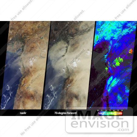
On October 18, 2002, a large dust plume extended across countries bordering the eastern Mediterranean Sea. Information on the horizontal and vertical extent of the dust are provided by these views from the Multi-angle Imaging SpectroRadiometer (MISR). The left-hand panel portrays the scene as viewed by the instrument's vertical-viewing (nadir) camera. Here only some of the dust over eastern Syria and southeastern Turkey can be discerned. The dust is much more obvious in the center panel, which is a view from MISR's most steeply forward-looking camera. In addition, this perspective makes shadows cast by clouds onto the dust layer more apparent, providing a visual clue that the dust is at a lower altitude than these clouds. The right-hand panel is an elevation field derived from automated MISR stereoscopic processing, in which the heights of clouds and certain parts of the dust plume are retrieved. Because the stereoscopic approach makes use of features within the images that exhibit spatial contrast, heights for much of the dust plume (as well as the ocean surface) could not be retrieved, and these areas are shown in dark gray. Clouds within the image area are situated between about 2 and 5.5 kilometers above sea level, and the dust is located below most of the cloud, at heights of about 1.5 kilometers or less. When the stereo retrieval determines that a location is at a near-surface altitude, digital terrain elevation data are displayed instead. The highest clouds in this scene appear as the orange and red areas, and mountainous regions are displayed in light blue and green. Photo Credit: NASA/GSFC/LaRC/JPL, MISR Team [0003-0701-0121-3826] by 0003
|
Keywords
dust, dust plume, dust shrouds, dust shrouds the eastern mediterranean, eastern mediterranean, environment, environmental, geography, jpl, mediterranean, nasa, place turkey, syria, turkey, turkey place
|
|


