
|
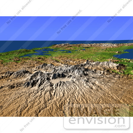
This perspective view shows central Panama, with the remnants of the extinct volcano El Valle in the foreground and the Caribbean Sea in the distance. El Valle underwent an explosive eruption about 3 million years ago, forming a crater 5 kilometers (3.1 miles) across, one of the largest in the Americas. The crater subsequently filled with water forming a huge lake, but about 12,000 years ago a breach at the present site of the waterfall Choro de las Mozas caused it to drain, forming the present valley. Within the crater is the town of El Valle de Anton, whose 600-meter (1,968-foot) elevation and resulting cooler climate make it a popular tourist and vacation site. The lake in the distance is Lake Gatun, at the west end of the Panama Canal. The canal itself extends to the southwest (to the right in this northeast facing view) but is hidden by the intervening terrain. This shaded relief perspective view was generated using topographic data from the Shuttle Radar Topography Mission (SRTM). A computer-generated artificial light source illuminates the elevation data to produce a pattern of light and shadows. Slopes facing the light appear bright, while those facing away are shaded. On flatter surfaces, the pattern of light and shadows can reveal subtle features in the terrain. Colors show the elevation as measured by SRTM, and range from green at the lowest elevations to white at the highest elevations. Photo Credit: NASA/JPL-Caltech [0003-0701-0121-3238] by 0003
|
Keywords
caribbean sea, central panama, choro de las mozas, el valle, el valle de anton, el valle volcano, geography, jpl, lake gatun, nasa, panama, panama canal, volcano el valle
|
|


