La Plata, Maryland #2820


#2820 La Plata, Maryland by JVPD
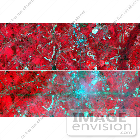
On Sunday, April 28, a category F5 tornado cut an East-West path through La Plata, Maryland, killing 5 and injuring more than 100. These two images acquired by NASA's Terra satellite Advanced Spaceborne Thermal Emission and Reflection Radiometer (ASTER) show a 6-by-17.8-kilometer (3.7-by-11.1-mile) area centered on the town. The top image was acquired on May 12, 2001, and the bottom on May 3, 2002. The bands used for the image portray vegetation in red, and bare fields and urban areas in blue-green. The dark turquoise swath cutting across the 2002 image is the track of the tornado, where the vegetation was ripped up and removed.

Photo Credit: NASA/GSFC/METI/ERSDAC/JAROS, and U.S./Japan ASTER Science Team [0003-0701-0121-2507] by 0003

Similar Images:

#3573 Great Wall of China From Space by JVPD
#19245 Photo of the Artificial Palm Island, Palm Jumeirah, on the Persian Gulf in Dubai by JVPD
#3253 Lost Hills by JVPD
#25455 Stock Photo of a Vetical Cropped Image of the State of Florida as Seen From Space by JVPD
#2898 Pulau Kimaam, West Papua by JVPD
#26949 Stock Photography of a Map of the Contiguous United States of America and the Great Lakes by JVPD
#35500 Geography Stock Photo Of The Strait Of Magellan, Chile As Seen From Space by JVPD
#2882 Bosporus Strait and Istanbul, Turkey by JVPD
#2685 Picture of World Globes - Three Views of Earth by JVPD
#3343 Cape Cod From Space by JVPD
#3619 Cape Cod From Space by JVPD
#3298 Mexicali, Calexico by JVPD
#3323 Liquefaction Effects, Bhuj Earthquake by JVPD
#3239 Republic of Fiji by JVPD
#3626 Boston From Space by JVPD
More Geography Photos

Keywords

category f5 tornado, earth science, f5 tornado, geography, jpl, la plata, la plata maryland, maryland, nasa, tornado, tornadoes