
|
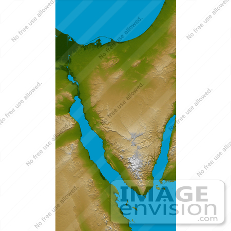
The Sinai Peninsula, located between Africa and Asia, is a result of those two continents pulling apart from each other. Earth's crust is cracking, stretching, and lowering along the two northern branches of the Red Sea, namely the Gulf of Suez, seen here on the west (left), and the Gulf of Aqaba, seen to the east (right). This color-coded shaded relief image shows the triangular nature of the peninsula, with the coast of the Mediterranean Sea forming the northern side of the triangle. The Suez Canal can be seen as the narrow vertical blue line in the upper left connecting the Red Sea to the Mediterranean. The peninsula is divided into three distinct parts; the northern region consisting chiefly of sandstone, plains and hills, the central area dominated by the Tih Plateau, and the mountainous southern region where towering peaks abound. Much of the Sinai is deeply dissected by river valleys, or wadis, that eroded during an earlier geologic period and break the surface of the plateau into a series of detached massifs with a few scattered oases. Two visualization methods were combined to produce the image: shading and color coding of topographic height. The shade image was derived by computing topographic slope in the northwest-southeast direction, so that northwest slopes appear bright and southeast slopes appear dark. Color coding is directly related to topographic height, with green at the lower elevations, rising through yellow and tan, to white at the highest elevations. Photo Credit: NASA/JPL/NIMA [0003-0701-0100-2234] by 0003
|
Keywords
africa, asia, canal, earth science, geography, gulf of aqaba, gulf of suez, jpl, mediterranean sea, nasa, peninsula, red sea, sinai peninsula, suez canal, tih plateau
|
|


