
|
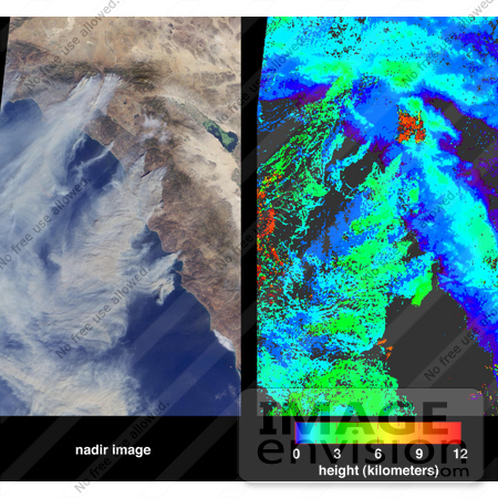
Large plumes of smoke rising from devastating wildfires burning near Los Angeles and San Diego on Sunday, October 26, 2003, are highlighted in this set of images from the Multi-angle Imaging SpectroRadiometer (MISR). These images include a natural color view from MISR's nadir camera (left) and an automated stereo height retrieval (right). The tops of the smoke plumes range in altitude from 500 - 3000 meters, and the stereo retrieval clearly differentiates the smoke from patches of high-altitude cirrus. Plumes are apparent from fires burning near the California-Mexico border, San Diego, Camp Pendleton, the foothills of the San Bernardino Mountains, and in and around Simi Valley. The majority of the smoke is coming from the fires near San Diego and the San Bernardino Mountains. Photo Credit: NASA/GSFC/LaRC/JPL, MISR Team [0003-0612-3120-0903] by 0003
|
Keywords
california, california wildfires, camp pendleton, earth science, environment, environmental, jpl, los angeles, nasa, plumes of smoke, san bernardino mountains, san diego, simi valley, smoke, smoke plume, wildfire, wildfires
|
|


