
|
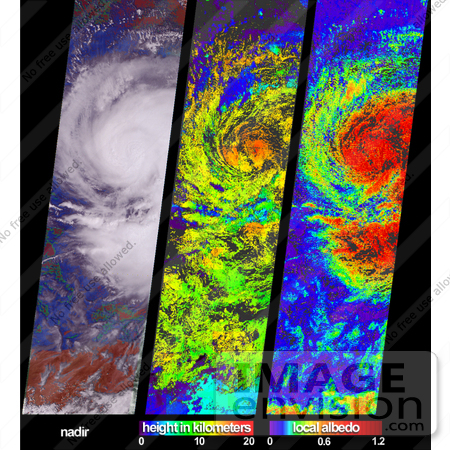
These views of Hurricane Isidore were acquired by the Multi-angle Imaging SpectroRadiometer (MISR) on September 20, 2002. After bringing large-scale flooding to western Cuba, Isidore was upgraded (on September 21) from a tropical storm to a category 3 hurricane. Sweeping westward to Mexico's Yucatan Peninsula, the hurricane caused major destruction and left hundreds of thousands of people homeless. Although weakened after passing over the Yucatan landmass, Isidore regained strength as it moved northward over the Gulf of Mexico. At left is a colorful visualization of cloud extent that superimposes MISR's radiometric camera-by-camera cloud mask (RCCM) over natural-color radiance imagery, both derived from data acquired with the instrument's vertical-viewing (nadir) camera. Using brightness and statistical metrics, the RCCM is one of several techniques MISR uses to determine whether an area is clear or cloudy. In this rendition, the RCCM has been color-coded, and purple = cloudy with high confidence, blue = cloudy with low confidence, green = clear with low confidence, and red = clear with high confidence. Photo Credit: NASA/GSFC/LaRC/JPL, MISR Team [0003-0701-0121-2845] by 0003
|
Keywords
earth science, hurricane, hurricane isidore, hurricanes, isidore, jpl, nasa, storms, the clouds of isidore, weather
|
|


