
|
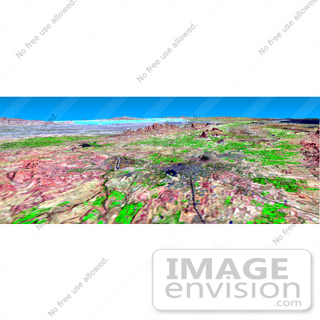
This perspective view shows the city of Bhuj, India, in the foreground (gray area). Bhuj and many other nearby towns and cities were almost completely destroyed by the shaking of an earthquake in western India on January 26, 2001. This magnitude 7.6 earthquake was the deadliest in the history of India with some 20,000 fatalities and over a million homes damaged or destroyed. The epicenter of the earthquake was in the area in the background of this view. Bhuj was the historical capital of the Kachchh region, and the Bhuj airport is the prominent dark line with light borders to the left of the center of the image. Highways and rivers appear as dark lines. Vegetation appears bright green in this false-color Landsat image. The Gulf of Kachchh (or Kutch) is the dark blue area in the upper right corner of the image. The hills reach up to 500 meters (1,500 feet) elevation. The light blue area in the background center of the image is low-lying salt flats called the Rann of Kachchh. Photo Credit: NASA/JPL/NIMA [0003-0701-0722-5818] by 0003
|
Keywords
bhuj, bhuj airport, bhuj india, earth science, earthquake, earthquakes, geography, gulf of kachchh, gulf of kutch, india, jpl, kachchh, kachchh region, nasa, rann of kachchh, salt flats
|
|


