|
TERMS OF USE:
This free image can only be used for non-commercial, personal
website use only. THIS IMAGE CANNOT BE
used in galleries, downloaded to your computer, posted on sites for
others to use, manipulated, downsized, or upsized. If you are confused about the
terms of use or have any questions then contact us before using the image.
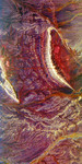
Free Picture: Central Plain, Oman
|
Description
NASA image of the Central Plain, Oman. Bright, arc-shaped limestone hills and complex, branching drainage patterns dominate this three-frequency space radar image of a desert area in the north central plain of Oman. The hill along the left side of the image, called Jabal Fuhud, lies just south of the town of Fuhud, which appears as small bright rectangular features. The thin red lines that can be seen radiating out from this town are roads. The "u"-shaped hill in the right center of the image is called Jabal Natih. Layers in the limestone appear as stripes which parallel the crest of the hill. This region is an active area of petroleum production because these geological structures form natural traps for oil and gas. The branching patterns on the image are ancient drainage channels that formed when the climate in this area was much wetter. Two large dry river channels, called wadis, appear on the image. Wadi Umayri is the yellow stripe at the lower right corner of the image. A second orange-colored wadi runs from right to left below the two sets of hills. The bright yellow patterns between the wadis are areas of bedrock covered with a thin layer of sand. These rocks would not be visible in conventional satellite images or photographs. This image is centered at 22.25 degrees north latitude, 56.58 degrees east longitude. The area shown is approximately 42 kilometers by 78 kilometers (26 miles by 48 miles). North is toward the upper right. The colors are assigned to different radar frequencies and polarizations as follows: red is L-band, horizontally transmitted and received; green is C-band, horizontally transmitted and vertically received; and blue is X-band, vertically transmitted and received.
Keywords
central plain, central plain oman, fuhud, geography, jabal fuhud, jabal natih, jpl, oman, radar image, radar images, wadi umayri, nasa, free photography, free photo, free photos, free picture, free pictures, free image, free images
|
Similar Free geography Pictures
|
|
|
|


