|
TERMS OF USE:
This free image can only be used for non-commercial, personal
website use only. THIS IMAGE CANNOT BE
used in galleries, downloaded to your computer, posted on sites for
others to use, manipulated, downsized, or upsized. If you are confused about the
terms of use or have any questions then contact us before using the image.
Free Picture: Hampton Roads, Virginia
|
Description
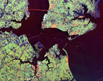
NASA radar image of the Hampton Roads, Virginia.
This radar image shows the Hampton Roads, Virginia region, where the James River (upper left center) flows into the Chesapeake Bay. The city of Norfolk is the bright area on the peninsula in the lower center. Norfolk is home to a large naval base, part of which can be seen as the bright white port facilities near the center of the image. The cities of Hampton and Newport News occupy the peninsula in the upper right of the image. The dark blue areas on this peninsula are the runways of Langley Air Force Base, which also houses NASA's Langley Research Center. Forested areas, including suburbs, appear as green on the image. Cities appear as green, white and orange. The purple areas along the shorelines are wetlands; blue areas are cleared for agricultural use. Faint ship wakes can be seen in the water behind ships entering and leaving Hampton Roads. Scientists are using radar images like this one to study delicate coastal environments and the effects of urbanization and other human activities on the ecosystem and landscape.
Keywords
chesapeake bay, from space, geography, hampton, hampton roads, hampton roads virginia, james river, jpl, langley air force base, newport news, norfolk, radar image, radar images, view from space, virginia, nasa, free photography, free photo, free photos, free picture, free pictures, free image, free images
|
Similar Free geography Pictures
|
|
|
|


