|
TERMS OF USE:
This free image can only be used for non-commercial, personal
website use only. THIS IMAGE CANNOT BE
used in galleries, downloaded to your computer, posted on sites for
others to use, manipulated, downsized, or upsized. If you are confused about the
terms of use or have any questions then contact us before using the image.
Free Picture: Honolulu, Hawaii
|
Description
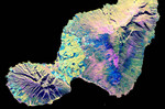
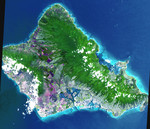
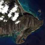
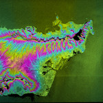
Radar image of the city of Honolulu, Hawaii and adjacent areas on the island of Oahu. Honolulu lies on the south shore of the island, right of center of the image. Just below the center is Pearl Harbor, marked by several inlets and bays. Runways of the airport can be seen to the right of Pearl Harbor. Diamond Head, an extinct volcanic crater, is a blue circle along the coast right of center. The Koolau mountain range runs through the center of the image. The steep cliffs on the north side of the range are thought to be remnants of massive landslides that ripped apart the volcanic mountains that built the island thousands of years ago. On the north shore of the island are the Mokapu Peninsula and Kaneohe Bay.
Keywords
diamond head, geography, hawaii, honolulu, honolulu hawaii, jpl, kaneohe bay, koolau, koolau mountain range, mokapu peninsula, oahu, pearl harbor, radar image, radar images, nasa, free photography, free photo, free photos, free picture, free pictures, free image, free images
|
Similar Free hawaii Pictures
|
|
|
|