|
TERMS OF USE:
This free image can only be used for non-commercial, personal
website use only. THIS IMAGE CANNOT BE
used in galleries, downloaded to your computer, posted on sites for
others to use, manipulated, downsized, or upsized. If you are confused about the
terms of use or have any questions then contact us before using the image.
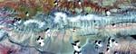
Free Picture: Antelope Valley
|
Description
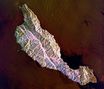
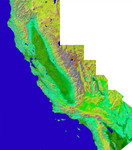
NASA image of Antelope Valley, Calif, featuring faults and dry lakes. Antelope Valley is bounded by two of the most active faults in California: the Garlock fault, which fronts the distant mountains in this view, and the San Andreas fault, part of which is seen bounding the mountains in the left foreground. In this view, Antelope Valley is in the foreground, the Tehachapi Mountains form the left skyline, and ranges within the southernmost Sierra Nevada form the right skyline. Antelope Valley is directly north of Los Angeles and is the westernmost part of the Mojave Desert. It is a closed basin. Stream flow here ends at Rosamond and Rogers dry lakes, which appear bright white. Dry lakes like these are common where tectonic activity raises and lowers parts of the Earth's crust, and thus the topographic surface, faster than stream flow can fill depressions with water, and then overflow and cut escape channels to other basins and eventually to the sea. The Sierra Nevada, the Tehachapi, and other mountains generally to the west create a rain shadow desert here. Thus, the area definitely has the active tectonics and low rainfall combination that leads to closed basin topography.
Keywords
antelope valley, antelope valley ca, antelope valley california, ca, calif, california, fault, faults, garlock fault, geography, jpl, rogers, rogers dry lake, rosamond, rosamond and rogers dry lakes, rosamond dry lake, san andreas fault, sierra nevada, sierra nevada mountains, tehachapi, tehachapi mountains, valley, nasa, free photography, free photo, free photos, free picture, free pictures, free image, free images
|
Similar Free Pictures of faults
|
|
|
|