|
TERMS OF USE:
This free image can only be used for non-commercial, personal
website use only. THIS IMAGE CANNOT BE
used in galleries, downloaded to your computer, posted on sites for
others to use, manipulated, downsized, or upsized. If you are confused about the
terms of use or have any questions then contact us before using the image.
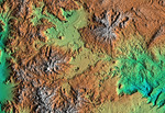
Free Picture: Patagonia, Argentina
|
Description
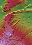
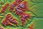
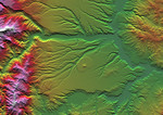
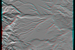
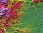
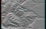
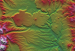
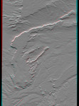
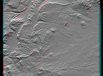
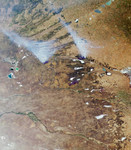
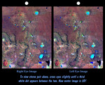
3d NASA image of the Meseta de Somuncura, a broad plateau capped by basalt. Near its western edge is evidence of multiple volcanic events and a complex erosion history. Most notable are the long, narrow-, and winding lava flows that run across most of the right side of the image. These formed from low-viscosity lava that flowed down gullies over fairly flat terrain. Later, erosion of the landscape continued and the solidified flows were more resistant than the older surrounding rocks. Consequently, the flows became the ridges we see here. This natural process of converting gullies to ridges is called topographic inversion. See image PIA02755 (upper left corner) for a good example of topographic inversion in its earlier stages. Other features seen here include numerous and varied closed depressions. The regional drainage is not well integrated, and drainage ends up in salty lakes(blue if shallow, black if deep). Wind streaks indicate that winds blow toward the east (right) and blow salt grains off the lakebeds when dry. The bowtie pattern in the upper left has resulted from differing grazing practices among fenced fields. This cross-eyed stereoscopic image pair was generated using topographic data from the Shuttle Radar Topography Mission, combined with an enhanced Landsat 7satellite color image. The topography data are used to create two differing perspectives of a single image, one perspective for each eye. In doing so, each point in the image is shifted slightly, depending on its elevation. When stereoscopically merged, the result is a vertically exaggerated view of the Earth's surface in its full three dimensions.
Keywords
3d, argentina, basalt plateau, geography, jpl, los menucos, meseta de somuncura, patagonia, nasa, free photography, free photo, free photos, free picture, free pictures, free image, free images
|
Similar Free argentina Pictures
|
|
|
|