|
TERMS OF USE:
This free image can only be used for non-commercial, personal
website use only. THIS IMAGE CANNOT BE
used in galleries, downloaded to your computer, posted on sites for
others to use, manipulated, downsized, or upsized. If you are confused about the
terms of use or have any questions then contact us before using the image.
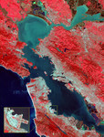
Free Picture: San Francisco Bay Area
|
Description
Image of the San Francisco Bay region on March 3rd 2000. The combination of bands portrays vegetation in red, and urban areas in gray. Sediment in the Suisun Bay, San Pablo Bay, San Francisco Bay, and the Pacific Ocean shows up as lighter shades of blue. Along the west coast of the San Francisco Peninsula, strong surf can be seen as a white fringe along the shoreline. A powerful rip tide is visible extending westward from Daly City into the Pacific Ocean. In the lower right corner, the wetlands of the South San Francisco Bay National Wildlife Refuge appear as large dark blue and brown polygons. The high spatial resolution of ASTER allows fine detail to be observed in the scene. The main bridges of the area (San Mateo, San Francisco-Oakland Bay, Golden Gate, Richmond-San Rafael, Benicia-Martinez, and Carquinez) are easily picked out, connecting the different communities in the Bay area. Shadows of the towers along the Bay Bridge can be seen over the adjacent bay water. With enlargement the entire road network can be easily mapped; individual buildings are visible, including the shadows of the high-rises in downtown San Francisco. Inset: This enlargement of the San Francisco Airport highlights the high spatial resolution of ASTER. With further enlargement and careful examination, airplanes can be seen at the terminals.
Keywords
airport, airports, bay area, bay bridge, benicia-martinez bridge, ca, calif, california, carquinez bridge, daly city, geography, golden gate bridge, jpl, pacific ocean, richmond-san rafael bridge, san fran, san francisco, san francisco airport, san francisco bay, san francisco bay area, san francisco peninsula, san francisco-oakland bay bridge, san mateo, san pablo bay, sf, sf airport, sf bay area, south san francisco bay national wildlife refuge, suisun bay, wetlands, nasa, free photography, free photo, free photos, free picture, free pictures, free image, free images
|
Similar Free san francisco Pictures
|
|
|
|