|
TERMS OF USE:
This free image can only be used for non-commercial, personal
website use only. THIS IMAGE CANNOT BE
used in galleries, downloaded to your computer, posted on sites for
others to use, manipulated, downsized, or upsized. If you are confused about the
terms of use or have any questions then contact us before using the image.
Free Picture: San Francisco Bay Area, CA
|
Description
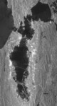
The San Francisco Bay Area in California and its surroundings are shown in this radar image from the Shuttle Radar Topography Mission (SRTM). On this image, smooth areas, such as the bay, lakes, roads and airport runways appear dark, while areas with buildings and trees appear bright. Downtown San Francisco is at the center and the city of Oakland is at the right across the San Francisco Bay. Some city areas, such as the South of Market district in San Francisco, appear bright due to the alignment of streets and buildings with respect to the incoming radar beam. Three of the bridges spanning the Bay are seen in this image. The Bay Bridge is in the center and extends from the city of San Francisco to Yerba Buena and Treasure Islands, and from there to Oakland. The Golden Gate Bridge is to the left and extends from San Francisco to Sausalito. The Richmond-San Rafael Bridge is in the upper right and extends from San Rafael to Richmond. Angel Island is the large island east of the Golden Gate Bridge, and lies north of the much smaller Alcatraz Island. The Alameda Naval Air Station is seen just below the Bay Bridge at the center of the image. Two major faults bounding the San Francisco-Oakland urban areas are visible on this image. The San Andreas fault, on the San Francisco peninsula, is seen on the left side of the image. The fault trace is the straight feature filled with linear reservoirs, which appear dark. The Hayward fault is the straight feature on the right side of the image between the urban areas and the hillier terrain to the east.
Keywords
alameda naval air station, alcatraz island, angel island, bay area, bay bridge, ca, calif, california, fault, faults, geography, golden gate bridge, hayward fault, jpl, oakland, richmond-san rafael bridge, san andreas fault, san francisco, san francisco bay, san francisco bay area, san francisco peninsula, san rafael, sausalito, treasure islands, yerba buena, nasa, free photography, free photo, free photos, free picture, free pictures, free image, free images
|
Similar Free san francisco Pictures
|
|
|
|