|
TERMS OF USE:
This free image can only be used for non-commercial, personal
website use only. THIS IMAGE CANNOT BE
used in galleries, downloaded to your computer, posted on sites for
others to use, manipulated, downsized, or upsized. If you are confused about the
terms of use or have any questions then contact us before using the image.
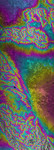
Free Picture: San Andreas Fault
|
Description
Radar image showing California's famous San Andreas Fault along the southwestern edge of the Mojave Desert, 75 kilometers (46 miles) north of downtown Los Angeles. The Lancaster/Palmdale area appears as bright patches just below the center of the image and the San Gabriel Mountains fill the lower left half of the image. At the extreme lower left is Pasadena. High resolution topographic data such as these are used by geologists to study the role of active tectonics in shaping the landscape, and to produce earthquake hazard maps.
Keywords
ca, calif, california, fault, faults, geography, jpl, lancaster, mojave desert, palmdale, pasadena, radar image, radar images, san andreas fault, san gabriel mountains, san gabriel mtns, nasa, free photography, free photo, free photos, free picture, free pictures, free image, free images
|
Similar Free geography Pictures
|
|
|
|


