|
TERMS OF USE:
This free image can only be used for non-commercial, personal
website use only. THIS IMAGE CANNOT BE
used in galleries, downloaded to your computer, posted on sites for
others to use, manipulated, downsized, or upsized. If you are confused about the
terms of use or have any questions then contact us before using the image.
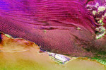
Free Picture: Namibia Sand Dunes
|
Description
Radar image of part of the vast Namib Sand Sea on the west coast of southern Africa, just northeast of the city of Luderitz, Namibia. The magenta areas in the image are fields of sand dunes, and the orange area along the bottom of the image is the surface of the South Atlantic Ocean. The region receives only a few centimeters (inches) of rain per year. In most radar images, sandy areas appear dark due to their smooth texture, but in this area the sand is organized into steep dunes, causing bright radar reflections off the dune "faces." This effect is especially pronounced in the lower center of the image, where many glints of bright radar reflections are seen. Radar images of this hyper-arid region have been used to image sub-surface features, such as abandoned stream courses. The bright green features in the upper right are rocky hills poking through the sand sea. The peninsula in the lower center, near Hottentott Bay, is Diaz Point; Elizabeth Point is south of Diaz Point.
Keywords
africa, diaz point, dunes, elizabeth point, geography, hottentott bay, jpl, luderitz, namib sand sea, namibia, namibia sand dunes, sand dunes, nasa, free photography, free photo, free photos, free picture, free pictures, free image, free images
|
Similar Free geography Pictures
|
|
|
|


