|
TERMS OF USE:
This free image can only be used for non-commercial, personal
website use only. THIS IMAGE CANNOT BE
used in galleries, downloaded to your computer, posted on sites for
others to use, manipulated, downsized, or upsized. If you are confused about the
terms of use or have any questions then contact us before using the image.
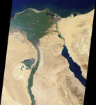
Free Picture: The Nile
|
Description
This image of the northern portion of the Nile River was captured by MISR's nadir camera on January 30 2001 (Terra orbit 5956). The Nile is the longest river in the world, extending for about 6700 kilometers from its headwaters in the highlands of eastern Africa. At the apex of the fertile Nile River Delta is the Egyptian capital city of Cairo. To the west are the Great Pyramids of Giza. North of here the Nile branches into two distributaries, the Rosetta to the west and the Damietta to the east. Also visible in this image is the Suez Canal, a shipping waterway connecting Port Said on the Mediterranean Sea with the Gulf of Suez. The Gulf is an arm of the Red Sea, and is located on the righthand side of the picture.
Keywords
africa, cairo, damietta, egypt, geography, giza, great pyramids, great pyramids of giza, gulf, gulf of suez, jpl, mediterranean sea, nile, nile river, nile river delta, port said, pyramids, red sea, river, rivers, rosetta, suez canal, the nile, nasa, free photography, free photo, free photos, free picture, free pictures, free image, free images
|
Similar Free geography Pictures
|
|
|
|


