|
TERMS OF USE:
This free image can only be used for non-commercial, personal
website use only. THIS IMAGE CANNOT BE
used in galleries, downloaded to your computer, posted on sites for
others to use, manipulated, downsized, or upsized. If you are confused about the
terms of use or have any questions then contact us before using the image.
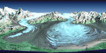
Free Picture: Pine Island Glacier
|
Description
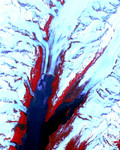
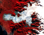
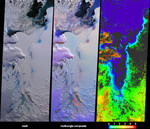
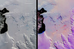
This pair of MISR images of the Pine Island Glacier in western Antarctica was acquired on December 12, 2000 during Terra orbit 5246. At left is a conventional, true-color image from the downward-looking (nadir) camera. The false-color image at right is a composite of red band data taken by the MISR forward 60-degree, nadir, and aftward 60-degree cameras, displayed in red, green, and blue colors, respectively. Color variations in the left (true-color) image highlight spectral differences. In the multi-angle composite, on the other hand, color variations act as a proxy for differences in the angular reflectance properties of the scene. In this representation, clouds show up as light purple. Blue to orange gradations on the surface indicate a transition in ice texture from smooth to rough. For example, the bright orange "carrot-like" features are rough crevasses on the glacier's tongue. In the conventional nadir view, the blue ice labeled "rough crevasses" and "smooth blue ice" exhibit similar coloration, but the multi-angle composite reveals their different textures, with the smoother ice appearing dark purple instead of orange. This could be an indicator of different mechanisms by which this ice is exposed. The multi-angle view also reveals subtle roughness variations on the frozen sea ice between the glacier and the open water in Pine Island Bay. To the left of the "icebergs" label are chunks of floating ice. Additionally, smaller icebergs embedded in the frozen sea ice are visible below and to the right of the label. These small icebergs are associated with dark streaks. Analysis of the illumination geometry suggests that these streaks are surface features, not shadows. Wind-driven motion and thinning of the sea ice in the vicinity of the icebergs is one possible explanation. Recently, Robert Bindschadler, a glaciologist at the NASA Goddard Space Flight Center discovered in Landsat 7 imagery a newly-formed crack traversing the Pine Island Glacier. This crack is vis
Keywords
antarctica, earth science, ice, iceberg, icebergs, jpl, pine island bay, pine island glacier, pine island glacier antarctica, nasa, free photography, free photo, free photos, free picture, free pictures, free image, free images
|
Similar Free glacier Pictures
|
|
|
|