|
TERMS OF USE:
This free image can only be used for non-commercial, personal
website use only. THIS IMAGE CANNOT BE
used in galleries, downloaded to your computer, posted on sites for
others to use, manipulated, downsized, or upsized. If you are confused about the
terms of use or have any questions then contact us before using the image.
Free Picture: Fire in the Land of 100,000 Lakes
|
Description
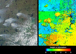
Fire season in Manitoba, Canada lasts from April until October, and numerous smoke plumes caused by lightning strikes are captured in these Multi-angle Imaging SpectroRadiometer (MISR) views of the northwestern part of the province. The data were acquired on June 20, 2001 during Terra orbit 8015. On the left is a true-color image acquired by MISR's vertical-viewing (nadir) camera. The area covered measures 232 kilometers X 80 kilometers. The greenish area on the right-hand side of the image, partially obscured by clouds, is Southern Indian Lake. This landscape is predominantly boreal, and contains deciduous and evergreen conifer forests, deciduous broadleaved forests, fens, and lakes. Tree species found within the area include white and black spruce, jack pine, tamarack, willow, and birch. Human population density is sparse, averaging about 1 person per 10 square kilometers. The large plume northwest of Big Sand Lake, above image center, was reported to be under control on June 20, whereas the plume at lower left, to the west of Gold Sand Lake, was classified "out of control." In the next two days, an additional 27 out-of-control fires in the area were started by lightning strikes arriving with as low-moving northerly cold front. By June 29, all but six of the fires had been brought under control. The picture on the right is a height field derived using automated computer processing of the data from several of MISR's cameras. The results indicate that the smoke plumes reach altitudes a few kilometers above the surface terrain, nearly as high as the cumulus cloud field in the lower right quadrant. The height retrievals make use of geometric parallax associated with observing the features at multiple angles. A few artifacts are visible in this early version of the MISR stereoscopic product, e.g., linear discontinuities in the elevation field, isolated elevation "spikes" (appearing as red), and black areas where no result was obtained. Nevertheless, this first version
Keywords
big sand lake, canada, environment, environmental, fire, fire season, fires, geography, gold sand lake, jpl, manitoba, smoke plumes, southern indian lake, wildfire, wildfires, nasa, free photography, free photo, free photos, free picture, free pictures, free image, free images
|
Similar Free geography Pictures
|
|
|
|


