|
TERMS OF USE:
This free image can only be used for non-commercial, personal
website use only. THIS IMAGE CANNOT BE
used in galleries, downloaded to your computer, posted on sites for
others to use, manipulated, downsized, or upsized. If you are confused about the
terms of use or have any questions then contact us before using the image.
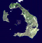
Free Picture: Santorini, Greece
|
Description
This ASTER image of Santorini was acquired on November 21, 2000 and covers an area of 18 by 18 km. The eruption of Santorini in 1650 B.C. was one of the largest in the last 10,000 years. About 30 cubic kilometers of magma was erupted, forming a plinian column 36 km high. The removal of such a large volume of magma caused the volcano to collapse, producing a caldera. Ash fell over a large area of the eastern Mediterranean. The eruption probably caused the end of the Minoan civilization on the island of Crete. The largest island is Thera, and the smaller is Therasia. The Kameni Islands (dark in the image center) formed after the caldera, with the most recent eruptions occurring in 1950.
Keywords
geography, greece, island, islands, jpl, kameni islands, santorini, santorini greece, the kameni islands, thera, therasia, nasa, free photography, free photo, free photos, free picture, free pictures, free image, free images
|
Similar Free geography Pictures
|
|
|
|


