|
TERMS OF USE:
This free image can only be used for non-commercial, personal
website use only. THIS IMAGE CANNOT BE
used in galleries, downloaded to your computer, posted on sites for
others to use, manipulated, downsized, or upsized. If you are confused about the
terms of use or have any questions then contact us before using the image.
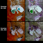
Free Picture: Fluctuations of Lake Eyre, South Australia
|
Description
Lake Eyre is a large salt lake situated between two deserts in one of Australia's driest regions. However, this low-lying lake attracts run-off from one of the largest inland drainage systems in the world. The drainage basin is very responsive to rainfall variations, and changes dramatically with Australia's inter-annual weather fluctuations. When Lake Eyre fills,as it did in 1989, it is temporarily Australia's largest lake, and becomes dense with birds, frogs and colorful plant life. The Lake responds to extended dry periods (often associated with El Nino events) by drying completely. These four images from the Multi-angle Imaging SpectroRadiometer contrast the lake area at the start of the austral summers of 2000 and 2002. The top two panels portray the region as it appeared on December 9, 2000. Heavy rains in the first part of 2000 caused both the north and south sections of the lake to fill partially and the northern part of the lake still contained significant standing water by the time these data were acquired. The bottom panels were captured on November 29, 2002. Rainfall during 2002 was significantly below average, although showers occurring in the week before the image was acquired helped alleviate this condition slightly. The left-hand panels portray the area as it appeared to MISR's vertical-viewing (nadir) camera, and are false-color views comprised of data from the near-infrared, green and blue channels. Here, wet and/or moist surfaces appear blue-green, since water selectively absorbs longer wavelengths such as near-infrared. The right-hand panels are multi-angle composites created with red band data from MISR's 60-degree forward, nadir and 60-degree backward-viewing cameras, displayed as red, green and blue, respectively. In these multi-angle composites, color variations serve as a proxy for changes in angular reflectance, and indicate textural properties of the surface related to roughness and/or moisture content. Data from the two dates were process
Keywords
australia, el nino, environment, environmental, geography, jpl, lake eyre, nasa, salt lake, south australia, fluctuations of lake eyre, free photography, free photo, free photos, free picture, free pictures, free image, free images
|
Similar Free geography Pictures
|
|
|
|


