|
TERMS OF USE:
This free image can only be used for non-commercial, personal
website use only. THIS IMAGE CANNOT BE
used in galleries, downloaded to your computer, posted on sites for
others to use, manipulated, downsized, or upsized. If you are confused about the
terms of use or have any questions then contact us before using the image.
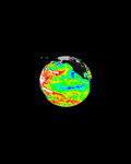
Free Picture: Smoke over Rondonia, Brazil
|
Description
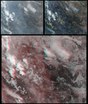
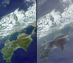
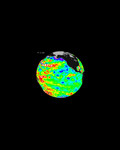
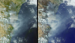
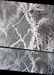
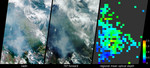
In the Brazilian state of Rondonia, scientists have gathered to study gases and airborne particles produced in the tropics. Between September and November 2002, they are conducting integrated airborne and ground-based measurements aimed at better understanding the role these constituents play in Earth's climate. These views from the Multi-angle Imaging SpectroRadiometer (MISR) show extensive plumes of fine particles emanating from burning vegetation within Rondonia. The data were acquired on September 15, the official start date for the Amazon burning season, and one week into the field study, which is called the Cooperative Large-scale-biosphere-atmosphere Airborne Regional Experiment, or CLAIRE. The left-hand panel is a natural-color view acquired by MISR's vertical-viewing (nadir) camera. The center image covers the same geographic area, as seen by the 70-degree forward-viewing MISR camera. The appearance of smoke and haze is enhanced in the oblique view, whereas the herringbone patterns of deforestation are more evident in the nadir image. Due to geometric parallax, clouds appear to move relative to the ground between these two images. At right is a map of aerosol optical depth, a measure of the amount of particulates in the atmosphere, derived from the MISR multi-angle views. Haze distributed across Rondonia shows up as light blue and green pixels across the region. Places where clouds or other factors precluded an aerosol retrieval are shown in dark grey. The main measurement site for the CLAIRE campaign is a field near the town of Ji-Parana, somewhat below and to the right of the MISR image centers. It is well-situated to observe the thick palls of smoke originating in dense vegetation to the south and east, at the eastern end of the Parque Nacional de Pacaas Novos. The CLAIRE aircraft will follow these plumes as they spread over the region, and will measure the changing characteristics of the smoke particles as they age. The southern edges of these images extend into Bolivia, where more fires are burning near the Brazil-Bolivia border. Clearer skies in the southeast corner of the image area are associated with higher-elevation lands along the Serra dos Parecis mountains.
Keywords
airborne particles, brazil, environment, environmental, fire, fires, gases, haze, jpl, nasa, rondonia, rondonia brazil, serra dos parecis mountains, smoke, smoke over rondonia brazil, smoke over rondonia, free photography, free photo, free photos, free picture, free pictures, free image, free images
|
Similar Free environmental Pictures
|
|
|
|