|
TERMS OF USE:
This free image can only be used for non-commercial, personal
website use only. THIS IMAGE CANNOT BE
used in galleries, downloaded to your computer, posted on sites for
others to use, manipulated, downsized, or upsized. If you are confused about the
terms of use or have any questions then contact us before using the image.
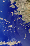
Free Picture: Greek islands of the Aegean Sea
|
Description
The Greek islands of the Aegean Sea, scattered across 800 kilometers from north to south and between Greece and western Turkey, are uniquely situated at the intersection of Europe, Asia and Africa. This image from the Multi-angle Imaging SpectroRadiometer includes many of the islands of the East Aegean, Sporades, Cyclades, Dodecanese and Crete, as well as part of mainland Turkey. Many sites important to ancient and modern history can be found here. The largest modern city in the Aegean coast is Izmir, situated about one quarter of the image length from the top, southeast of the large three-pronged island of Lesvos. Izmir can be located as a bright coastal area near the greenish waters of the Izmir Bay, about one quarter of the image length from the top, southeast of Lesvos. The coastal areas around this cosmopolitan Turkish city were a center of Ionian culture from the 11th century BC, and at the top of the image (north of Lesvos), once stood the ancient city of Troy. The image was acquired before the onset of the winter rains, on September 30, 2001, but dense vegetation is never very abundant in the arid Mediterranean climate. The sharpness and clarity of the view also indicate dry, clear air. Some vegetative changes can be detected between the western or southern islands such as Crete (the large island along the bottom of the image) and those closer to the Turkish coast which appear comparatively green. Volcanic activities are evident by the form of the islands of Santorini. This small group of islands shaped like a broken ring are situated to the right and below image center. Santorini's Thera volcano erupted around 1640 BC, and the rim of the caldera collapsed, forming the shape of the islands as they exist today.
Keywords
aegean sea, city of troy, crete, cyclades, dodecanese, geography, greece, greek islands, greek islands of the aegean sea, island, islands, izmir, jpl, lesvos, nasa, place turkey, santorini, sporades, thera volcano, turkey, turkey place, islands in the midst of the world, free photography, free photo, free photos, free picture, free pictures, free image, free images
|
Similar Free geography Pictures
|
|
|
|


