|
TERMS OF USE:
This free image can only be used for non-commercial, personal
website use only. THIS IMAGE CANNOT BE
used in galleries, downloaded to your computer, posted on sites for
others to use, manipulated, downsized, or upsized. If you are confused about the
terms of use or have any questions then contact us before using the image.
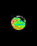
Free Picture: Smoke from Fires in Southern Mexico
|
Description
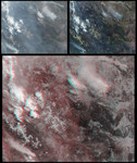
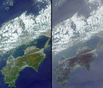
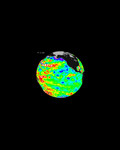
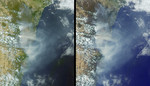
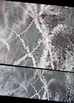
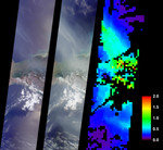
On May 2, 2002, numerous fires in southern Mexico sent smoke drifting northward over the Gulf of Mexico. These views from the Multi-angle Imaging SpectroRadiometer illustrate the smoke extent over parts of the Gulf and the southern Mexican states of Tabasco, Campeche and Chiapas. At the same time, dozens of other fires were also burning in the Yucatan Peninsula and across Central America. A similar situation occurred in May and June of 1998, when Central American fires resulted in air quality warnings for several U.S. States. The image on the left is a natural color view acquired by MISR's vertical-viewing (nadir) camera. Smoke is visible, but sunglint in some ocean areas makes detection difficult. The middle image, on the other hand, is a natural color view acquired by MISR's 70-degree backward-viewing camera; its oblique view angle simultaneously suppresses sunglint and enhances the smoke. A map of aerosol optical depth, a measurement of the abundance of atmospheric particulates, is provided on the right. This quantity is retrieved using an automated computer algorithm that takes advantage of MISR's multi-angle capability. Areas where no retrieval occurred are shown in black.
Keywords
campeche, chiapas, environment, environmental, fire, fires, gulf of mexico, jpl, mexico, nasa, smoke, tabasco, smoke from fires in southern mexico, free photography, free photo, free photos, free picture, free pictures, free image, free images
|
Similar Free environmental Pictures
|
|
|
|