|
TERMS OF USE:
This free image can only be used for non-commercial, personal
website use only. THIS IMAGE CANNOT BE
used in galleries, downloaded to your computer, posted on sites for
others to use, manipulated, downsized, or upsized. If you are confused about the
terms of use or have any questions then contact us before using the image.
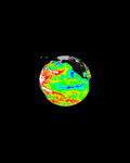
Free Picture: MISR Global Aerosol Observations
|
Description
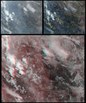
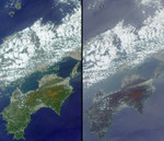
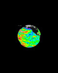
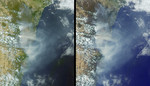
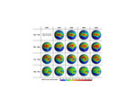
Five years of atmospheric aerosol data are available as global aerosol maps from NASA's Multi-angle Imaging SpectroRadiometer (MISR). These 19 global panels show the seasonal-average distribution of atmospheric aerosol amount across Africa and the Atlantic Ocean; such global maps are also available for all other parts of the planet, and for monthly as well as seasonal time increments. The measurements capture airborne particles in the entire atmospheric column, for sub-visible sizes ranging from tiny smoke particles to "medium" dust (about 0.5 to 2.5 microns). Such particles are produced by forest fires, deserts, volcanoes, breaking ocean waves, and urban and industrial pollution sources. MISR retrieves aerosol amount with high accuracy at mid-visible wavelengths, even over urban areas and bright desert source regions, in addition to obtaining some information about particle size and shape, from the varying scene brightness over nine different view angles and four wavelengths. These maps were generated from data acquired between March 2000 and November 2004, and show column-integrated aerosol optical depth (also known as optical thickness) averaged over half-degree by half-degree grid cell areas (about 60 kilometer rectangles at low latitudes). The color scale indicates the range of optical depths, from relatively clear skies in blue and purple, to hazier atmospheres in red, orange, yellow or green. Black pixels indicate missing results due to persistent seasonal cloud cover. The MISR aerosol algorithm uses both stereoscopic and spectral brightness techniques to identify and screen out cloudy pixels. This five-year data sequence has special significance to the MISR Mission -- it is released this week to mark the fifth anniversary since MISR began taking science data, on February 24 2000. Despite easily identified changes from season to season, the seasonal patterns are remarkably similar from year to year. Between December and February there are relatively clear ski
Keywords
aerosol, aerosol map, aerosol maps, aerosols, atmospheric aerosol, earth, earth science, environment, environmental, global aerosol map, global aerosol maps, jpl, misr, nasa, misr global aerosol observations, free photography, free photo, free photos, free picture, free pictures, free image, free images
|
Similar Free environmental Pictures
|
|
|
|