|
TERMS OF USE:
This free image can only be used for non-commercial, personal
website use only. THIS IMAGE CANNOT BE
used in galleries, downloaded to your computer, posted on sites for
others to use, manipulated, downsized, or upsized. If you are confused about the
terms of use or have any questions then contact us before using the image.
Free Picture: Flooding in the Aftermath of Hurricane Katrina
|
Description
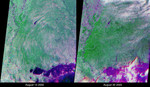
These views of the Louisiana and Mississippi regions were acquired before and one day after Katrina made landfall along the Gulf of Mexico coast, and highlight many of the changes to the rivers and vegetation that occurred between the two views. The images were acquired by NASA's Multi-angle Imaging SpectroRadiometer (MISR) on August 14 and August 30, 2005. These multiangular, multispectral false-color composites were created using red band data from MISR's 46° backward and forward-viewing cameras, and near-infrared data from MISR's nadir camera. Such a display causes water bodies and inundated soil to appear in blue and purple hues, and highly vegetated areas to appear bright green. The scene differentiation is a result of both spectral effects (living vegetation is highly reflective at near-infrared wavelengths whereas water is absorbing) and of angular effects (wet surfaces preferentially forward scatter sunlight). The two images were processed identically and extend from the regions of Greenville, Mississippi (upper left) to Mobile Bay, Alabama (lower right). There are numerous rivers along the Mississippi coast that were not apparent in the pre-Katrina image; the most dramatic of these is a new inlet in the Pascagoula River that was not apparent before Katrina. The post-Katrina flooding along the edges of Lake Pontchartrain and the city of New Orleans is also apparent. In addition, the agricultural lands along the Mississippi floodplain in the upper left exhibit stronger near-infrared brightness before Katrina. After Katrina, many of these agricultural areas exhibit a stronger signal to MISR's oblique cameras, indicating the presence of inundated soil throughout the floodplain. Note that clouds appear in a different spot for each view angle due to a parallax effect resulting from their height above the surface.
Keywords
aftermath, aftermath of hurricane katrina, earth science, flood, flooding, floods, greenville, hurricane katrina, jpl, katrina, katrina aftermath, lake pontchartrain, louisiana, mississippi, mobile bay, nasa, new orleans, pascagoula river, post katrina, weather, flooding in the aftermath of hurricane katrina, free photography, free photo, free photos, free picture, free pictures, free image, free images
|
Similar Free geography Pictures
|
|
|
|


