|
TERMS OF USE:
This free image can only be used for non-commercial, personal
website use only. THIS IMAGE CANNOT BE
used in galleries, downloaded to your computer, posted on sites for
others to use, manipulated, downsized, or upsized. If you are confused about the
terms of use or have any questions then contact us before using the image.
Free Picture: Agricultural Patterns
|
Description
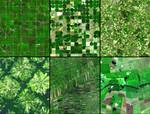
Around the world, agricultural practices have developed as a function of topography, soil type, crop type, annual rainfall, and tradition. This montage of six images from the Advanced Spaceborne Thermal Emission and Reflection Radiometer (ASTER) sensor on NASA’s Terra satellite shows differences in field geometry and size in different parts of the world. In Minnesota (first), the very regular grid pattern reflects early nineteenth-century surveying; the size of the fields was determined by the need to have a big enough area to make the use of machinery efficient. Dirt roads separate the fields. In Kansas (second), center-pivot irrigation is responsible for the field pattern. Water is drawn up from a well and fed through a tube attached to metal frames. The metal frames are on wheels, and electric motors roll the frames around in a circle, pivoting around the water source, spraying water as they go. In northwest Germany (third), the small size and random pattern of fields is leftover from the Middle Ages. A village or town appears in the left side of the image. Near Santa Cruz, Bolivia (fourth), the pie-shape or radial-pattern fields are part of a planned settlement scheme in a rainforest area. At the center of each unit is a small community, which is surrounded by fields. A small buffer of forest separates the settlements from one another. Outside of Bangkok, Thailand (fifth), rice paddies fed by an extensive network of canals that is hundreds of years old appear as small skinny rectangular fields. Some fields appear flooded (deep purple), which is part of the growing cycle of rice plants. And in the woodland-savanna region known as the Cerrado (sixth) in southern Brazil, the cheap cost of land and its flatness have resulted in enormous farms and large field sizes. In the large image, each ASTER scene covers an area of 10.5 by 12 kilometers.
Keywords
agricultural, agricultural patterns, agriculture, bangkok, bolivia, brazil, cerrado, corn crop, corn crops, crop, crop circle, crop circles, crop circles in kansas, cropland, croplands, crops, finney county, germany, kansas, kansas crop circles, nasa, ogallala aquifer, phenomenon, phenomenons, rice paddies, santa cruz bolivia, sorghum crop, sorghum crops, thailand, wheat crop, wheat crops, minnesota, free photography, free photo, free photos, free picture, free pictures, free image, free images
|
Similar Free agriculture Pictures
|
|
|
|