|
TERMS OF USE:
This free image can only be used for non-commercial, personal
website use only. THIS IMAGE CANNOT BE
used in galleries, downloaded to your computer, posted on sites for
others to use, manipulated, downsized, or upsized. If you are confused about the
terms of use or have any questions then contact us before using the image.
Free Picture: New Zealand
|
Description
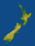
New Zealand straddles the juncture of the Indo-Australian and Pacific tectonic plates, two of Earth's major crustal plates. The two plates generally converge in subduction zones, but in a scissor-like pattern, with the Indo-Austalian plate overriding the Pacific plate to the north and the Pacific plate overriding the Indo-Australian plate to the south. New Zealand is "what happens" in between at and near the cross point of this scissor pattern. Here the convergence has built two major islands that together exhibit very active volcanoes and fault systems, and these geologic features are very evident in the topographic pattern. The North Island lies at the southern end of the west-over-east (Indo-Australian over Pacific) plate convergence. The Pacific plate dives under the North Island and this subduction process leads to melting of rocks at depth, the rise of magma to the surface, and the formation of volcanoes and other geothermal features. Most notable are Mount Taranaki on the west coast, and Mounts Ruapehu, Ngauruhoe, and Tongariro just south of the island's centerpoint, all of which are shown with white peaks in this display. The Rotorua geothermal field occurs further northeast and is evident here as a scattering of comparatively small bumps created by smaller volcanic eruptions. The South Island straddles the cross point of the subduction scissor pattern and prominently features a fault system that connects the two subduction zones. (The east-over-west (Pacific over Indo-Australian) plate convergence generally occurs south of the South Island.) The Alpine fault is the major strand of this fault system along most of the length of the island, near and generally paralleling the west coast. Its impact upon the topography is unmistakable, forming an extremely sharp and straight northwest boundary to New Zealand's tallest mountains, the Southern Alps. Although offsets on the Alpine fault are generally right-lateral (35-40 millimeters per year) and thus consistent wi
Keywords
earth science, geography, island, islands, jpl, mount ngauruhoe, mount ruapehu, mount taranaki, mount tongariro, nasa, ngauruhoe, nz, ruapehu, southern alps, taranaki, tongariro, new zealand, free photography, free photo, free photos, free picture, free pictures, free image, free images
|
Similar Free geography Pictures
|
|
|
|


