|
TERMS OF USE:
This free image can only be used for non-commercial, personal
website use only. THIS IMAGE CANNOT BE
used in galleries, downloaded to your computer, posted on sites for
others to use, manipulated, downsized, or upsized. If you are confused about the
terms of use or have any questions then contact us before using the image.
Free Picture: Australia
|
Description
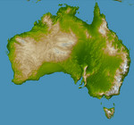
Australia is the world's smallest, flattest, and (after Antarctica) driest continent, but at 7.7 million square kilometers (3.0 million square miles) it is also the sixth largest country. Its low average elevation (300 meters, or less than 1000 feet) is caused by its position near the center of a tectonic plate, where there are no volcanic or other geologic forces of the type that raise the topography of other continents. In fact Australia is the only continent without any current volcanic activity at all - the last eruption took place 1400 years ago at Mt. Gambier. The Australian continent is also one of the oldest land masses, with some of its erosion-exposed bedrock age dated at more than 3 billion years. More than one-fifth of the land area is desert, with more than two-thirds being classified as arid or semi-arid and unsuitable for settlement. The coldest regions are in the highlands and tablelands of Tasmania and the Australian Alps at the southeastern corner of the continent, location of Australia's highest point, Mt. Kosciusko (2228 meters, or 7310 feet.) Prominent features of Australia include the Lake Eyre basin, the darker green region visible in the center-right. At 16 meters (52 feet) below sea level this depression is one of the largest inland drainage systems in the world, covering more than 1.3 million square kilometers (500,000 square miles). The mountain range near the east coast is called the Great Dividing Range, forming a watershed between east and west flowing rivers. Erosion has created deep valleys, gorges and waterfalls in this range where rivers tumble over escarpments on their way to the sea. The crescent shaped uniform green region in the south, just left of center, is the Nullarbor Plain, a low-lying limestone plateau which is so flat that the Trans-Australian Railway runs through it in a straight line for more than 483 kilometers (300 miles).
Keywords
australian alps, continent, earth science, geography, great dividing range, jpl, kosciusko, lake eyre basin, mount kosciusko, mt kosciusko, nasa, nullarbor plain, tasmania, australia, free photography, free photo, free photos, free picture, free pictures, free image, free images
|
Similar Free geography Pictures
|
|
|
|


