|
TERMS OF USE:
This free image can only be used for non-commercial, personal
website use only. THIS IMAGE CANNOT BE
used in galleries, downloaded to your computer, posted on sites for
others to use, manipulated, downsized, or upsized. If you are confused about the
terms of use or have any questions then contact us before using the image.
Free Picture: Virgin Islands
|
Description
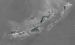
St. Thomas, St. John, Tortola, and Virgin Gorda are the four main islands (lower left to upper right) of this map-view anaglyph of the U.S. Virgin Islands and British Virgin Islands, along the northeast perimeter of the Caribbean Sea. For this view, a nearly cloud-free Landsat image was draped over elevation data from the Shuttle Radar Topography Mission (SRTM), and shading derived from the SRTM data was added to enhance the topographic expression. Coral reefs fringe the islands in many locations and appear as bright patterns in near-shore waters. Tropical vegetation appears fairly dark with smooth tones, as compared to the brighter speckled patterns of towns and other developments. As in much of the world, topography is the primary factor in the pattern of land use development in the Virgin Islands. Topography across most of the islands is quite rugged, and although the steep slopes create a scenic setting, they crowd most development into the small areas of low relief terrain, generally along the shoreline. The topographic pattern also affects water supply, wastewater disposal, landfill locations, road construction, and most other features of the development infrastructure. Topography also defines the natural drainage pattern, which is the major consideration in anticipating tropical storm water runoff dangers, as well as the dangers of heightened sediment impacts upon the adjacent coral reefs.
Keywords
anaglyph, british virgin islands, caribbean, caribbean sea, earth science, geography, island, islands, jpl, nasa, st john, st thomas, tortola, us virgin islands, virgin gorda, virgin islands, free photography, free photo, free photos, free picture, free pictures, free image, free images
|
Similar Free geography Pictures
|
|
|
|


