|
TERMS OF USE:
This free image can only be used for non-commercial, personal
website use only. THIS IMAGE CANNOT BE
used in galleries, downloaded to your computer, posted on sites for
others to use, manipulated, downsized, or upsized. If you are confused about the
terms of use or have any questions then contact us before using the image.
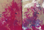
Free Picture: Drought and Burn Scars in Southeastern Australia
|
Description
More than 2 million acres were consumed by hundreds of fires between December 2002 and February 2003 in southeastern Australia's national parks, forests, foothills and city suburbs. These images were acquired on February 14, 2002 (left) and February 17, 2003 (right) by the Multi-angle Imaging SpectroRadiometer (MISR) instrument onboard NASA's Terra satellite. The year 2002 was one of Australia's hottest and driest on record, and the acreage burnt during the summer 2002-2003 fire season in Victoria, the Australian Capital Territory and southern New South Wales, is the largest since 1938-1939, when more than 3 million acres were scorched. The extent of the burnt area and the dry conditions as of February 2003 are indicated by these contrasting false-color views. Both image panels display data from the near-infrared, red and blue spectral bands of MISR's downward-viewing (nadir) camera, as red, green and blue, respectively. This display technique causes healthy vegetation to appear red and burnt areas to show as dark brown. The data displayed from the two dates were processed identically to preserve relative brightness variations. Vegetation changes related to the dry conditions (not related to the brown burn scars) are also indicated in the February 2003 panel, where many previously red areas exhibit instead the pale yellow-brown of the underlying soils and geology. Significant reduction in the surface area of several large and important water bodies are also apparent. The diminished extent of Lake Hume (along the left-hand edge) in the later date provides a good example.
Keywords
australia, burn scars, drought, earth science, environment, environmental, geography, jpl, lake hume, nasa, new south wales, nsw, victoria, drought and burn scars in southeastern australia, free photography, free photo, free photos, free picture, free pictures, free image, free images
|
Similar Free geography Pictures
|
|
|
|


