|
TERMS OF USE:
This free image can only be used for non-commercial, personal
website use only. THIS IMAGE CANNOT BE
used in galleries, downloaded to your computer, posted on sites for
others to use, manipulated, downsized, or upsized. If you are confused about the
terms of use or have any questions then contact us before using the image.
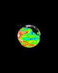
Free Picture: Saharan Dust Storm
|
Description
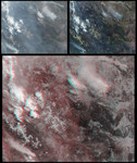
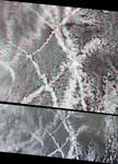
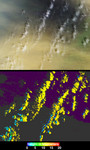
On March 2, 2003, near-surface winds carried a large amount of Saharan dust aloft and transported the material westward over the Atlantic Ocean. These observations from the Multi-angle Imaging SpectroRadiometer (MISR) aboard NASA's Terra satellite depict an area near the Cape Verde Islands (situated about 700 kilometers off of Africa's western coast) and provide images of the dust plume along with measurements of its height and motion. Tracking the three-dimensional extent and motion of air masses containing dust or other types of aerosols provides data that can be used to verify and improve computer simulations of particulate transport over large distances, with application to enhancing our understanding of the effects of such particles on meteorology, ocean biological productivity, and human health. MISR images the Earth by measuring the spatial patterns of reflected sunlight. In the upper panel of the still image pair, the observations are displayed as a natural-color snapshot from MISR's vertical-viewing (nadir) camera. High-altitude cirrus clouds cast shadows on the underlying ocean and dust layer, which are visible in shades of blue and tan, respectively. In the lower panel, heights derived from automated stereoscopic processing of MISR's multi-angle imagery show the cirrus clouds (yellow areas) to be situated about 12 kilometers above sea level. The distinctive spatial patterns of these clouds provide the necessary contrast to enable automated feature matching between images acquired at different view angles. For most of the dust layer, which is spatially much more homogeneous, the stereoscopic approach was unable to retrieve elevation data. However, the edges of shadows cast by the cirrus clouds onto the dust (indicated by blue and cyan pixels) provide sufficient spatial contrast for a retrieval of the dust layer's height, and indicate that the top of layer is only about 2.5 kilometers above sea level.
Keywords
cape verde islands, dust storm, dust storms, earth science, environment, environmental, jpl, nasa, saharan dust, storm, storms, saharan dust storm, free photography, free photo, free photos, free picture, free pictures, free image, free images
|
Similar Free environmental Pictures
|
|
|
|