|
TERMS OF USE:
This free image can only be used for non-commercial, personal
website use only. THIS IMAGE CANNOT BE
used in galleries, downloaded to your computer, posted on sites for
others to use, manipulated, downsized, or upsized. If you are confused about the
terms of use or have any questions then contact us before using the image.
Free Picture: Mt. Elgon, Africa
|
Description
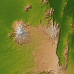
The striking contrast of geologic structures in Africa is shown in this shaded relief image of Mt. Elgon on the left and a section of the Great Rift Valley on the right. Mt. Elgon is a solitary extinct volcano straddling the border between Uganda and Kenya, and at 4,321 meters (14,178 feet) tall is the eighth highest mountain in Africa. It is positioned on the Pre-Cambriam bedrock of the Trans Nzoia Plateau, and is similar to other such volcanoes in East Africa in that it is associated with the formation of the Rift Valley. However one thing that sets Mt. Elgon apart is its age. Although there is no verifiable evidence of its earliest volcanic activity, Mt. Elgon is estimated to be at least 24 million years old, making it the oldest extinct volcano in East Africa. This presents a striking comparison to Mt. Kilimanjaro, the highest mountain in Africa at 5,895 meters (19,341 feet), which is just over one million years old. Judging by the diameter of its base, it is a common belief among geological experts that Mt. Elgon was once the highest mountains in Africa, however erosion has played a significant role in reducing the height to its present value. Juxtaposed with this impressive mountain is a section of the Great Rift Valley, a geological fault system that extends for about 4,830 kilometers (2,995 miles) from Syria to central Mozambique. Erosion has concealed some sections, but in some sections like that shown here, there are sheer cliffs several thousand feet high. The present configuration of the valley, which dates from the mid-Pleistocene epoch, results from a rifting process associated with thermal currents in the Earth's mantle.
Keywords
africa, earth science, east africa, elgon, geography, great rift valley, jpl, kenya, mount elgon, nasa, rift valley, trans nzoia plateau, uganda, volcano, volcanoes, mt elgon, free photography, free photo, free photos, free picture, free pictures, free image, free images
|
Similar Free geography Pictures
|
|
|
|


