|
TERMS OF USE:
This free image can only be used for non-commercial, personal
website use only. THIS IMAGE CANNOT BE
used in galleries, downloaded to your computer, posted on sites for
others to use, manipulated, downsized, or upsized. If you are confused about the
terms of use or have any questions then contact us before using the image.
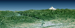
Free Picture: Portland, Mount Hood, Columbia River Gorge
|
Description
Portland, the largest city in Oregon, is located on the Columbia River at the northern end of the Willamette Valley. On clear days, Mount Hood highlights the Cascade Mountains backdrop to the east. The Columbia is the largest river in the American Northwest and is navigable up to and well beyond Portland. It is also the only river to fully cross the Cascade Range, and has carved the Columbia River Gorge, which is seen in the left-central part of this view. A series of dams along the river, at topographically favorable sites, provide substantial hydroelectric power to the region. This perspective view was generated using topographic data from the Shuttle Radar Topography Mission (SRTM), a Landsat satellite image, and a false sky. Topographic expression is vertically exaggerated two times.
Keywords
cascade mountains, cascade range, columbia river, columbia river gorge, earth science, geography, jpl, mount hood, mt hood, nasa, or, oregon, willamette valley, portland, free photography, free photo, free photos, free picture, free pictures, free image, free images
|
Similar Free geography Pictures
|
|
|
|


